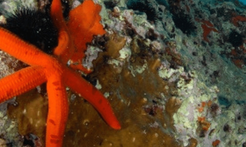
Area Marina Protetta Porto Cesareo
Una vera magia da Punta Prosciutto a Torre Inserraglio. Lungo 32 chilometri di costa si alternano spiagge bianche con dune maestose, ricoperte di gigli marini, a scogliere basse affacciate su un mare declinato in tutte le varianti d’azzurro.
E poi imponenti torri costiere, isolette e boschi, grotte sommerse e fondali tra i più belli del Mediterraneo, ricchi di coralligeno coloratissimo, praterie di posidonia, relitti e vari reperti archeologici, come le colonne greco-romane nell’insenatura di Torre Chianca. Dal 1997 Area Marina Protetta, è una delle più vaste d’Italia (ben 16.654 ettari) e preziosa per la grande biodiversità, con oltre 40 punti di immersione e vari “Sentieri Blu” individuati dai ricercatori della locale Stazione di Biologia Marina. A Porto Cesareo è stata scoperta perfino una piccola medusa immortale, capace di invertire il proprio ciclo biologico, la Turritopsis nutricula (tel. +39 0833 560144 – ampportocesareo.it).
🇬🇧 The Marine Protected Area Porto Cesareo
A real charm from Punta Prosciutto to Torre Inserraglio. Along 32 kilometers of coastline alternate white beaches with majestic dunes, covered with sea Lilies, low cliffs overlooking a sea declined in all shades of blue. And then imposing coastal towers, islets and forests, underwater caves and seabed among the most beautiful in the Mediterranean, rich in colorful coral, posidonia meadows, wrecks and various archaeological finds, such as the Greek-Roman columns in the inlet of Torre Chianca. Since 1997 it has been a Protected Marine Area, one of the largest in Italy (16,654 hectares) and precious for its great biodiversity, with over 40 diving spots and various “Blue Trails’ ‘ identified by the researchers of the local Marine Biology Station. In Porto Cesareo was even discovered a small immortal jellyfish, able to reverse its biological cycle, the Turritopsis nutricula (tel. +39 0833 560144 – ampportocesareo.it).
Parco Regionale Naturale di Porto Selvaggio e Palude del Capitano
Affacci spettacolari sul mare nel parco più antico di Puglia, dalla costa alta e rocciosa di Porto Selvaggio al paesaggio suggestivo intorno a Torre Inserraglio, fino alla Palude del Capitano, dove si ammirano rarità botaniche tra le spunnulate, depressioni nel terreno inondate di acque salmastre. Attraverso il grande bosco di pini d’Aleppo si arriva in una baia verde-blu con una minuscola spiaggia di ciottoli e lungo un sentiero sulla destra, che profuma di timo e ginepro, ci sono piccole insenature con sorgenti di acqua dolce ricche di anfratti ed ex cave messapiche e tra una conca e l’altra rivestita di salicornia si apre una piscina naturale tra gli scogli neri. Poco più in là, nella baia di Uluzzo con l’omonima torre, si trovano tante grotte ricche di reperti e pesci fossili, come quelle di Uluzzo e del Cavallo, che hanno un posto d’onore nella preistoria mondiale.
🇬🇧 Regional Natural Park of Porto Selvaggio and Palude del Capitano
Spectacular views of the sea in the oldest park in Apulia, from the high and rocky coast of Porto Selvaggio to the suggestive landscape around Torre Inserraglio, up to Palude del Capitano, where you can admire botanical rarities among the spunnulate, depressions in the ground flooded with brackish water. Through the large forest of Aleppo pines you arrive in a green-blue bay with a tiny pebble beach and along a path on the right, which smells of thyme and juniper, there are small coves with freshwater springs full of ravines and former Messapian quarries and between a hollow and another covered with glasswort opens a natural pool between the black rocks. A little further on, in the bay of Uluzzo with the homonymous tower, there are many caves rich in finds and fossil fish, such as those of Uluzzo and Cavallo, which have a place of honor in the world prehistory.
Parco Naturale Regionale Isola S. Andrea e Litorale di Punta Pizzo
È un vero ecomuseo per la grande varietà di ambienti e un’area sommersa sorprendente con la più ampia estensione di prateria di posidonia del Salento. Soffici lingue di sabbia sono protette da dune ricoperte di ginepro coccolone, gigli e campanelle. Poi il bosco di pini d’Aleppo e le dune fossili, che profumano di mirto, timo, rosmarino, colorate da ginestre spinose, fiordalisi cicalini e orchidee. Si nascondono tra Punta Pizzo e Punta della Suina resti di focolari preistorici e vasche millenarie, dove si lavorava la porpora. Dell’antica palude Li Foggi, un tempo estesa per 150 ettari e poi bonificata, restano solo cannucce e canali, un vero paradiso per gli uccelli migratori. Al tramonto dall’isoletta di S. Andrea, a meno di due miglia dal borgo di Gallipoli, si alzano in volo centinaia di gabbiani corsi, una specie rara, che qui nidifica. È uno scrigno prezioso di flora e fauna, con un faro ottocentesco, che illumina la rotta dei naviganti.
🇬🇧 Regional Natural Park of S. Andrea Island and Punta Pizzo Coastline
It is a real ecomuseum for the great variety of environments and an amazing underwater area with the widest extension of Posidonia prateria in Salento. Soft tongues of sand are protected by dunes covered with coconut juniper, lilies and bells. Then the forest of Aleppo pines and fossil dunes, which smell of myrtle, thyme, rosemary, colored by thorny broom, cornflowers and orchids. Between Punta Pizzo and Punta della Suina there are remains of prehistoric hearths and millenary basins, where purple was worked. Of the ancient Li Foggi swamp, once extended for 150 hectares and then reclaimed, only straws and canals remain, a real paradise for migratory birds. At sunset from the small island of S. Andrea, less than two miles from the town of Gallipoli, hundreds of Corsican seagulls, a rare species that nests here, take flight. It is a precious casket of flora and fauna, with a nineteenth-century lighthouse that illuminates the route of sailors.
Parco Naturale Regionale Litorale di Ugento
Camminare lungo sentieri che profumano di storia e archeologia, tra il mare e le serre salentine è il modo migliore per scoprire la ricchezza del Parco, che si estende per 1600 ettari. Alle basse scogliere ricoperte di salicornia e finocchio di mare da Località Pazze a Torre San Giovanni, seguono lunghe spiagge di sabbia dorata e dune fino a Lido Marini. Ovunque acqua cristallina e tramonti mozzafiato. E poi boschi e macchia mediterranea prima di entrare nell’area umida del parco, perfetta per il birdwatching. Dell’antica palude bonificata negli anni ’30 restano i bacini artificiali – Suddenna, Bianca, Ulmo, Spunderati e Rottacapozza – regno di uccelli, rane, tartarughe e campanule palustri, canne e giunchi. Poi la macchia lascia spazio alla gariga e pseudo steppa, appaiono le orchidee spontanee e i rapaci, ci si addentra nelle zone più impervie, quelle di serre e canaloni, speroni e gravine, come la suggestiva Specchia del Corno. 56 7
🇬🇧 Regional Natural Park Litoral of Ugento
Walking along pathways that smell of history and archaeology, between the sea and the Salento greenhouses is the best way to discover the richness of the Park, which covers 1600 hectares. The low cliffs covered with glasswort and sea fennel from Località Pazze to Torre San Giovanni are followed by long beaches of golden sand and dunes up to Lido Marini. Everywhere there is crystal clear water and breathtaking sunsets. And then woods and Mediterranean scrub before entering the humid area of the park, perfect for birdwatching. Of the ancient marshland reclaimed in the 1930s, the artificial basins remain – Suddenna, Bianca, Ulmo, Spunderati and Rottacapozza – the realm of birds, frogs, turtles and marsh bells, reeds and rushes. Then the scrub gives way to garrigue and pseudo-steppe, spontaneous orchids and birds of prey appear, and we enter the most impervious areas, those of greenhouses and gullies, spurs and ravines, such as the suggestive Specchia del Corno.
Parco Naturale Regionale Costa Otranto S.M. di Leuca Bosco di Tricase
Bianco, giallo, rosso, verde: in primavera la costa adriatica salentina, nei 60 chilometri del Parco da Otranto a Santa Maria di Leuca, è un trionfo di papaveri, asfodeli, anemoni, orchidee, margherite. Si susseguono antichi borghi e torri costiere, cattedrali e castelli, ville eclettiche, fari e grotte antichissime, muretti a secco e pajare. Riecheggiano nell’aria miti e leggende, come quella della quercia Vallonea di Tricase. A sud di Otranto ci sono scogliere a picco sul mare, i suggestivi canaloni di Porto Badisco, Acquaviva e il Ciolo, falesie dorate come Porto Miggiano, piscine nella roccia come Marina Serra. A passo lento o in bici si percorrono angoli selvaggi, dal Laghetto di Bauxite in un‘ex cava alla Baia delle Orte e sentieri a picco sul mare, come quello delle Cipolliane. Tuffi, bagni, veleggiate, immersioni nelle acque sulfuree di S. Cesarea Terme e giri in barca nelle grotte tra Punta Ristola e Punta Meliso (tel. +39 0836 926028 – parcootrantoleuca.it).
🇬🇧 Regional Natural Park Costa Otranto S.M. di Leuca Bosco di Tricase
White, yellow, red, green: in springtime the Adriatic coast of Salento, in the 60 kilometers of the Park from Otranto to Santa Maria di Leuca, is a triumph of poppies, asphodels, anemones, orchids, daisies. Ancient villages and coastal towers, cathedrals and castles, eclectic villas, lighthouses and ancient caves, dry stone walls and pajare follow one another. Myths and legends echo in the air, like that of the Vallonea oak in Tricase. South of Otranto there are cliffs overlooking the sea, the picturesque gullies of Porto Badisco, Acquaviva and Ciolo, golden cliffs such as Porto Miggiano, pools in the rock as Marina Serra. At a slow pace or by bike, you can explore wild corners, from the Bauxite Pond in a former quarry to the Bay of Orte and paths overlooking the sea, such as the Cipolliane. Diving, bathing, sailing, diving in the sulphurous waters of S. Cesarea Terme and boat trips in the caves between Punta Ristola and Punta Meliso (tel. +39 0836 926028 – parcootrantoleuca.it).
LE GROTTE MARINE
Roca Vecchia – Melendugno
Risuonano tante storie, tra mito e realtà, intorno alla Grotta della Poesia, una cavità carsica scavata dal mare, che arriva al suo interno attraverso tunnel sottomarini e appare come una bellissima piscina naturale. Il nome deriva dal greco medievale pòsis e significa “sorgente d’acqua dolce”. Sulle sue pareti e nella vicina grotta Poesia Piccola (non visitabile) si trovano simboli antichissimi, dall’età protostorica al II sec. a.C.: rappresentazioni di mani e piedi, figure antropomorfe, zoomorfe e astratte, ma anche tante iscrizioni votive in lingua messapica, latino e greco. Sono preghiere rivolte al Dio Thaotor Andirahas, affinché proteggesse durante le traversate in mare. Da visitare l’area archeologica stratificata dall’età del Bronzo al Rinascimento, con blocchi della cinta muraria e una necropoli con tombe del 1600 a.C.
Novaglie – Santa Maria di Leuca
Sono tutte diverse le grotte lungo la scogliera tra Marina di Novaglie e Santa Maria di Leuca: alcune attraversate da sorgenti di acqua dolce, altre ricche di reperti, poche accessibili da terra, molte sommerse e raggiungibili a nuoto o in barca. Alla luminosa Grotta Azzurra con riflessi cobalto si contrappone la Grotta del Diavolo, buia e stretta, segue la Grotta di Porto Vecchio e il suggestivo complesso delle Cipolliane con reperti del Paleolitico; quindi la Grotta Grande del Ciolo con imponente ingresso e il suo laghetto azzurro; il complesso delle Mannute tutte intercomunicanti e la Grotta della Vora o della Cattedrale, alta e con un grande foro luminoso. Verso Punta Meliso le Grotte Cazzafri hanno un’immensa volta ricca di stalattiti. Da Punta Ristola sul versante jonico si apre la Grotta Porcinara raggiungibile anche da terra con iscrizioni greche e latine; la Grotta del Diavolo ricca di reperti neolitici, le Tre Porte con arcate e una camera con stalattiti e stalagmiti. Resti di pachidermi, cocci bizantini e monete di bronzo rinvenuti nella Grotta dei Giganti, bagni refrigeranti nella Grotta della Stalla e poi in quella del Drago.
🇬🇧 SEA CAVES
Roca Vecchia – Melendugno
Many stories resonate, between myth and reality, around the Grotta della Poesia, a karst cavity excavated by the sea, which reaches its interior through underwater tunnels and appears as a beautiful natural pool. The name derives from the medieval Greek pòsis and means “source of fresh water”. On its walls and in the nearby cave Poesia Piccola (not open to visitors) there are very ancient symbols, from the protohistoric age to the II century B.C.: representations of hands and feet, anthropomorphic, zoomorphic and abstract figures, but also many votive inscriptions in Messapic language, Latin and Greek. They are prayers addressed to the God Thaotor Andirahas, so that he would protect them during sea crossings. To visit the archaeological area stratified from the Bronze Age to the Renaissance, with blocks of the city walls and a necropolis with tombs of 1600 BC.
Novaglie – Santa Maria di Leuca
The caves along the cliff between Marina di Novaglie and Santa Maria di Leuca are all different: some are crossed by fresh water springs, others are rich in artifacts, a few are accessible from land, many are submerged and can be reached by swimming or by boat. The bright Blue Cave with cobalt reflections contrasts with the Devil’s Cave, dark and narrow, followed by the Cave of Porto Vecchio and the impressive complex of Cipolliane with finds of Paleolithic, then the Great Cave of Ciolo with imposing entrance and its blue lake, the complex of Mannute all intercommunicating and the Cave of Vora or the Cathedral, high and with a large hole light. Towards Punta Meliso the Cazzafri Caves have an immense vault rich in stalactites. From Punta Ristola on the Ionian side there is the Porcinara Cave reachable also from the ground with Greek and Latin inscriptions; the Devil Cave rich in Neolithic finds, the Three Doors with arches and a chamber with stalactites and stalagmites. Remains of pachyderms, Byzantine shards and bronze coins found in the Cave of the Giants, cooling baths in the Cave of the Stable and then in that of the Dragon.